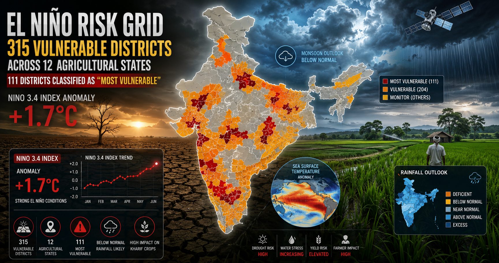
El Niño Risk Grid: Government Identifies 315 Vulnerable Districts Across 12 Agricultural States as Niño 3.4 Index Reaches +1.7°C
With the Niño 3.4 index anomaly rapidly climbing to +1.7°C, the government has mapped 315 vulnerable districts across 12 major agricultural states, including 111 "most vulnerable" zones. Learn what this means for Indian farmers, crop planning, water management, and climate resilience.
El Niño Risk Grid: Government Identifies 315 Vulnerable Districts Across 12 Agricultural States as Niño 3.4 Index Reaches +1.7°C
Introduction
India's agriculture remains highly dependent on the southwest monsoon. As the Niño 3.4 index anomaly rapidly climbs to +1.7°C, concerns over rainfall variability and crop productivity are increasing. In response, the government has prepared an El Niño Risk Grid identifying 315 vulnerable districts spread across 12 key agricultural states. Among these, 111 districts have been classified as "most vulnerable," requiring immediate preparedness and adaptive planning.
This climate-based risk assessment is designed to help governments, agricultural departments, extension workers, and farmers prepare for potential rainfall deficits, heat stress, and reduced soil moisture during the cropping season.
What Is the El Niño Risk Grid?
The El Niño Risk Grid is a district-level vulnerability assessment that combines climate forecasts with agricultural exposure.
The classification helps prioritize:
- Rainfall monitoring
- Water resource management
- Crop advisories
- Seed contingency planning
- Farmer awareness campaigns
- Input distribution
- Drought preparedness measures
Rather than treating every district equally, resources can now be directed toward regions facing the greatest climate risk.
Understanding the Niño 3.4 Index
What Does +1.7°C Mean?
The Niño 3.4 index measures sea surface temperature anomalies in the central equatorial Pacific Ocean.
A positive anomaly of +1.7°C indicates a strong El Niño phase, which has historically been associated with:
- Below-normal monsoon rainfall in parts of India
- Increased temperatures
- Longer dry spells
- Reduced reservoir recharge
- Higher irrigation demand
- Greater crop stress
Although El Niño does not guarantee drought everywhere, it significantly raises the probability of uneven rainfall distribution.
315 Vulnerable Districts Across 12 Agricultural States
The government's assessment covers major food-producing regions that contribute substantially to India's agricultural output.
These districts have been categorized based on factors such as:
Rainfall Dependence
Areas relying primarily on monsoon rainfall face higher exposure to prolonged dry periods.
Irrigation Availability
Districts with limited irrigation infrastructure are more vulnerable to rainfall deficits.
Cropping Pattern
Water-intensive crops may experience greater production risks during weak monsoon conditions.
Historical Climate Sensitivity
Past drought performance and rainfall variability have been incorporated into vulnerability assessments.
111 Districts Classified as "Most Vulnerable"
The highest-risk category includes districts expected to experience the greatest agricultural challenges if El Niño impacts intensify.
Potential risks include:
- Delayed sowing
- Poor germination
- Moisture stress
- Lower crop yields
- Increased pest pressure
- Livestock fodder shortages
- Groundwater depletion
Early intervention becomes essential in these districts.
Possible Impact on Major Crops
Rice
Delayed monsoon onset and uneven rainfall may affect transplanting schedules and productivity.
Pulses
Moisture stress during flowering can significantly reduce yields.
Oilseeds
Rainfed oilseed cultivation may face reduced soil moisture availability.
Maize
Heat stress combined with rainfall deficits may affect grain formation.
Cotton
Extended dry spells can increase irrigation demand and influence pest dynamics.
What Farmers Can Do
Farmers can improve resilience by adopting climate-smart practices.
Monitor Official Weather Advisories
Regular updates from meteorological agencies help optimize sowing and irrigation decisions.
Use Short-Duration Crop Varieties
Short-duration cultivars reduce exposure to prolonged dry conditions.
Improve Water Conservation
Practices such as mulching, farm ponds, and drip irrigation help maximize available water.
Diversify Cropping Systems
Crop diversification reduces dependence on a single rainfall-sensitive crop.
Strengthen Soil Health
Healthy soils retain moisture more effectively during dry spells.
Government Preparedness Measures
Authorities may strengthen preparedness through:
- District-level contingency crop plans
- Seed reserve management
- Drought monitoring
- Reservoir management
- Crop advisory dissemination
- Farmer awareness campaigns
- Enhanced extension services
Early planning can significantly reduce production losses.
Why Climate Intelligence Matters
Extreme weather events are becoming increasingly frequent. Climate intelligence enables farmers to make informed decisions before risks translate into financial losses.
Access to reliable weather information, crop advisories, and scientific recommendations helps improve resilience against uncertain monsoon conditions.
Conclusion
The identification of 315 vulnerable districts, including 111 "most vulnerable" zones, reflects a proactive approach to climate risk management. While a +1.7°C Niño 3.4 anomaly raises concern, preparedness, timely advisories, and climate-smart farming practices can help reduce potential impacts on agriculture.
Explore the Agriculture Intelligence Platform of Bharat - AGRIBOZ.
Register on https://www.agriboz.com to stay updated with agriculture news, weather intelligence, expert advisories, and climate-resilient farming solutions.
CTA
Explore the Agriculture Intelligence Platform of Bharat - AGRIBOZ.
Register on https://www.agriboz.com to access expert agriculture insights, weather updates, workshops, farming innovations, and climate-smart advisory services.
FAQ
What is the Niño 3.4 index?
It measures sea surface temperature anomalies in the central Pacific Ocean and is widely used to monitor El Niño and La Niña conditions.
Why is +1.7°C significant?
A +1.7°C anomaly represents a strong El Niño event that can influence rainfall patterns, temperatures, and agricultural productivity.
Why were 315 districts identified?
These districts are considered vulnerable based on climate exposure, rainfall dependence, irrigation availability, and agricultural sensitivity.
What does "most vulnerable" mean?
These districts face the highest potential agricultural risks from below-normal rainfall, heat stress, and moisture shortages.
How can farmers prepare?
By following weather advisories, conserving water, selecting suitable crop varieties, diversifying crops, and adopting climate-smart farming practices.
Explore the Agriculture Intelligence Platform of Bharat - AGRIBOZ.
Stay ahead of climate risks with expert weather intelligence, crop advisories, training programs, workshops, and smart farming resources.
Register on https://www.agriboz.com and become part of Bharat's growing agriculture intelligence ecosystem.
Q1. What is the El Niño Risk Grid? A. It is a government vulnerability assessment that identifies districts at higher risk of agricultural impacts due to El Niño-related weather anomalies.
Q2. What does a Niño 3.4 anomaly of +1.7°C indicate? A. It indicates a strong El Niño phase, which can increase the likelihood of below-normal rainfall and higher temperatures in many parts of India.
Q3. How many districts are considered highly vulnerable? A. Out of 315 vulnerable districts, 111 have been classified as the "most vulnerable."
Q4. Which crops are likely to be affected? A. Rainfed crops such as rice, pulses, oilseeds, maize, and cotton may face varying levels of stress depending on local rainfall conditions.
Q5. What should farmers do now? A. Farmers should monitor official weather advisories, adopt water-saving practices, consider suitable crop varieties, and prepare contingency plans.